This is the TRAINING website.
For current info please visit detroitmi.gov
block-detroitminew-views-block-news-events-block-1,News & Events*block-detroitminew-views-block-related-links-block-1,Related Links*block-detroitminew-views-block-video-playlist-block-1,Videos*documents-block,Documents*block-detroitminew-views-block-forms-block-1,Forms*block-views-block-faq-block-1,FAQs*block-detroitminew-views-block-district-map-block-1,District Map*block-views-block-council-office-directory-block-1,Office Directory*block-detroitminew-views-block-contacts-block-3,Contacts*block-detroitminew-views-block-contacts-block-4,Contacts*block-detroitminew-views-block-council-member-bio-block-1,Bio*block-detroitminew-views-block-sub-sections-block-1,Sections*block-detroitminew-views-block-web-apps-block-1,Web Apps*block-detroitminew-views-block-news-events-block-4,News*block-detroitminew-views-block-news-events-block-3-2,Events*block-detroitminew-views-block-contacts-special-block-1,Staff*block-detroitminew-views-block-statements-block-1,Statements*block-detroitminew-views-block-newsletters-block-1,Newsletters*block-detroitminew-views-block-newsletters-block-3,Ordinance*block-detroitminew-views-block-newsletters-block-2,Resolutions*block-detroitminew-views-block-newsletters-block-4,Memos
Mapping our city street by street
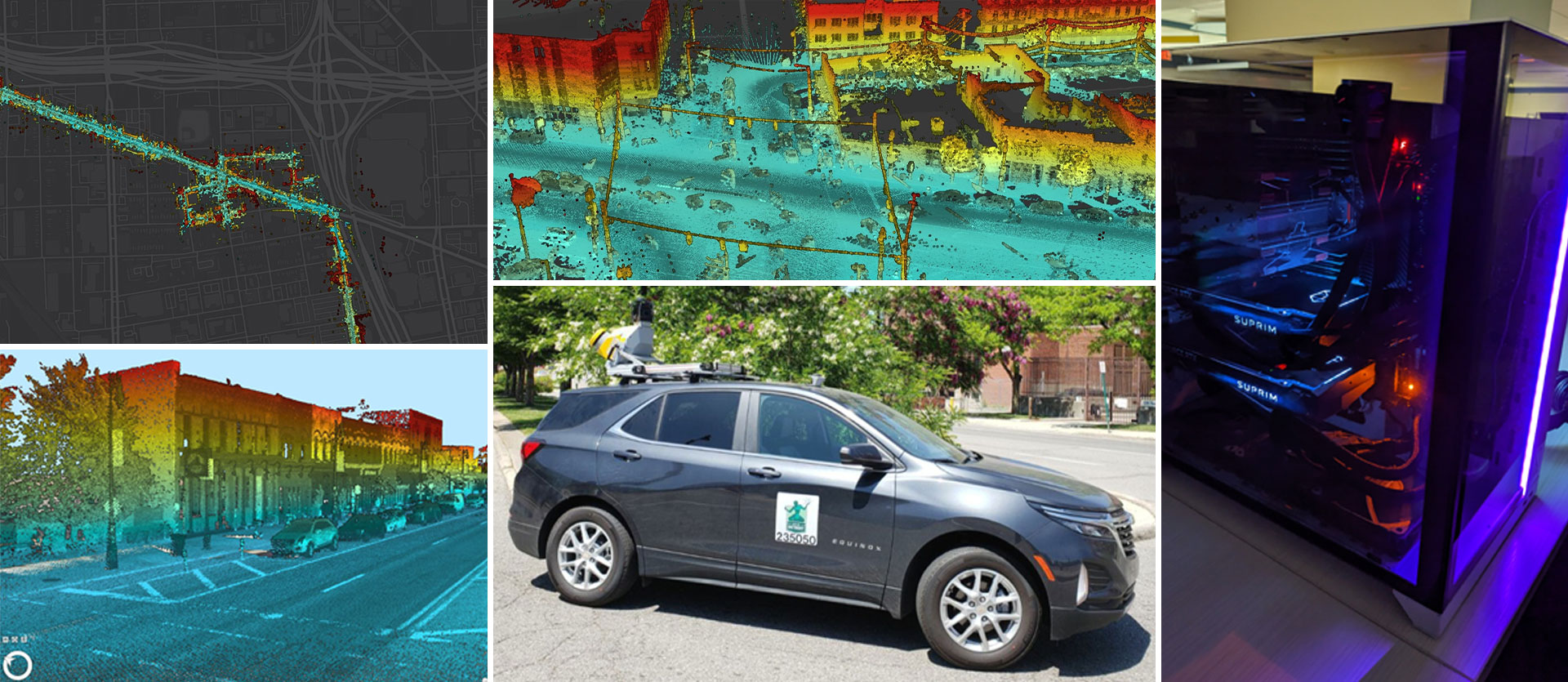
Detroit Street View (DSV) is a remote sensing program run by the Enterprise Geographic Information Systems (EGIS) Team within the Department of Innovation and Technology. The mission of Detroit Street View is “To continuously observe and document Detroit’s changing physical environment through remote sensing, resulting in freely available foundational data that empowers effective city operations, informed decision making, awareness, and innovation.”
DSV started in 2017 with capturing single-frame GoPro imagery along commercial corridors. The program was awarded a Mayor’s Innovation Grant in 2018, and expanded to include 360° panoramic imagery, terrestrial LiDAR, and eventually two full-time drivers. A generous grant from General Motors in 2022/2023 funded the purchase of upgraded camera and LiDAR equipment as well as a new vehicle.
The Detroit Street View program is based on a “Map Everything” philosophy. The program’s mobile mapping technology captures panoramic imagery (photographs looking in all directions) and LiDAR point clouds (3D models) of the visible world from a perspective shared by everyone – on the street. DSV realizes economies of scale and observational consistency for city operations by reducing the need for third party data purchases and minimizing the necessity of multiple visits to the same place to observe and collect data. For example, separate trips or data purchases may not be required to complete a blight assessment, traffic sign inventory, address investigation, and topographic survey all on the same block. Given comprehensive shared observational data, a wide variety of insights and foundational geospatial data can be derived, increasingly empowered by emerging machine learning and computer vision technologies. Repetitive collection additionally enables time-based insights like before-and-after analysis and change detection. Significant innovative opportunity exists to develop new ways to extract/analyze data and create value for a wide variety of applications.
Central to the Detroit Street View program is a core value of openness…that ‘Data should be appropriately transparent, available, and usable for employees, partners, and the public.’ Collected data is made available for public use while particular care is taken to preserve personal privacy through anonymization of images (blurring of faces and license plates). Additionally, Detroit Street View values educational opportunities for Detroiters and partnerships with external organizations that lead to further data development and innovation.
Please send inquiries about the Detroit Street View program to [email protected].
Report an inappropriate image on Detroit Street View
Detroit Street View takes personal privacy seriously. Images are captured in publicly accessible spaces (primarily streets) and personally identifiable information is carefully anonymized through blurring of faces and license plates. Also, because the program is focused on observing stationary physical assets, the frequency of data collection at any one location is generally too low to gain insight into individual human behavior.
Street view imagery is available from multiple other sources, but Detroit Street view is unique due to its frequency of data capture, coverage extent (including parking lots, alleys, etc.), and the type of data products generated.
Detroit Street View aims to capture every street at least once each year, and multiple times per year in priority areas/corridors (examples: areas with active development, scheduled blight investigation or remediation, demolition activities, etc.).
Anyone can access and use the data. Many departments and agencies within Detroit City Government may use this data for property assessments, asset inventories, emergency response, and general reference. Data is incorporated into multiple web applications and enterprise systems.
No. Department of Innovation and Technology staff do not have the authority to write tickets.
The best way to request city services is through the Improve Detroit App (Android, iOS) or by visiting the city website (www.detroitmi.gov).
Please send inquiries about the Detroit Street View program to [email protected].
GIS Support
[email protected]